


DrRec&Map - Drive recorder + Route Map app for iPhone and iPad
Developer: KATO GIKEN, K.K.
First release : 23 Apr 2014
App size: 1.36 Mb
Lets use as a drive recorder + route map the iPhone / iPad that is left over and model changes.
You can also use the iPhone / iPad of course active duty.
For current GPS location or Wi-Fi connection is available even iPhone / iPad, which ended the contract
You can take full advantage of as a drive recorder + route map.
Features:
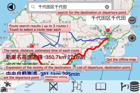
In an environment that can Wi-Fi connection , such as home , you can search and set driving directions
to the destination. You have stored in the iPhone / iPad in advance the map along the route . (- > Offline Map )
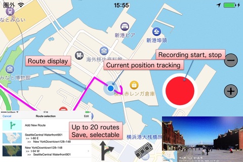
While driving , this app will display a map with a focus on travel sites at the same time as the drive recorder function . (Displays the offline map that had been acquired when it can not communicate . )
Make the record latitude, longitude and tracking of map that you follow the traveling area.
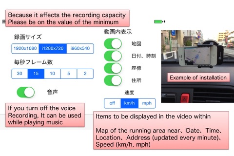
Displays the address, map, date , time , latitude , longitude and speed near the bottom of the recorded images .
It can be used while playing the music if you turn off the audio recording .
Can be displayed on the map the trajectory of the demonstration run, actually , of this app or camera roll as
a still image. you can be stored in the Documents folder .
Route map will be easy to see for 10 seconds , buttons disappear without operation .
Please Touch the screen to re- display .
The file sharing feature of iTunes, recorded video can be transferred to a PC directly from the document folder of this app.
How to operation:
Please see
http://www.katogiken-app.mimoza.jp/drrecmap2/
Restrictions:This app supports only landscape (horizontal).
If your iPhone/iPad can not communicate, including Wi-Fi, it does not allow changing the map type, route search, the display of the running track.
Driving, have the following restrictions: the case of the iPhone / iPad can not communicate.
Zoom map (change distance to the destination, depending on the model) only 2-4 stage
Map of the part that you scroll beyond the range map previously obtained (Offline map) can not be displayed.
None Address display of the recorded image.
There is a limit of the following addition to the above in the case of models that can not get the current position of the drive in without GPS as iPad Wi-Fi model.
No map of the recorded image, latitude, longitude display.
No tracking map that follows the running area.
Note:
If you want to use in the iPhone4s, please start by itself to end the other apps.
(Because it requires a relatively larger memory of the map display)